Michael Adler

 Email Address: the.eyrie@movistar.es

 Dear Sirs,


Please forgive the intrusion but I have only just now discovered that there is a Perutza River in your country.   Since I am closely related to the Perutz family (my grand mother was a Perutz), I would be most grateful to you indeed if you could tell me how and when this river came to be named after a member of the Perutz family.


Your attention would be most gratefully appreciated.


Yours very sincerely,


Michael Adler.  

Replies sorted oldest to newest

Perutza River, Guyana

/ Potaro-Siparuni Region

4°58'0" N, 60°0'0" W ~645m asl 18:13 (GYT - UTC/GMT--4)

Perutza River (Perutza River) is a stream (class H - Hydrographic) in Potaro-Siparuni Region (Potaro-Siparuni), Guyana (South America) with the region font code of Americas/Western Europe. It is located at an elevation of 645 meters above sea level.

Its coordinates are 4°58'0" N and 60°0'0" W in DMS (Degrees Minutes Seconds) or 4.96667 and -60 (in decimal degrees). Its UTM position is SF64 and its Joint Operation Graphics reference is NB21-13.

Current local time is 18:13; the sun rises at 08:56 and sets at 21:03 local time (America/Guyana UTC/GMT-4). The standard time zone for Perutza River is UTC/GMT-4
In 2019 DST starts on - and ends on -.

A Stream is a body of running water moving to a lower level in a channel on land.

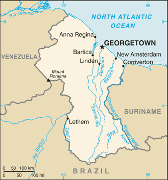
http://cdn.getamap.net/img/maps/country/large/gy-map.gif

Source -- http://www.getamap.net/maps/gu...aruni/_perutzariver/

FM
Last edited by Former Member

Add Reply

×
×
×
×
×
Link copied to your clipboard.
×
×